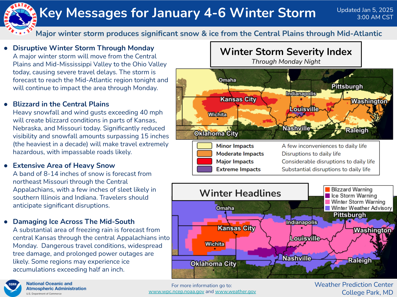
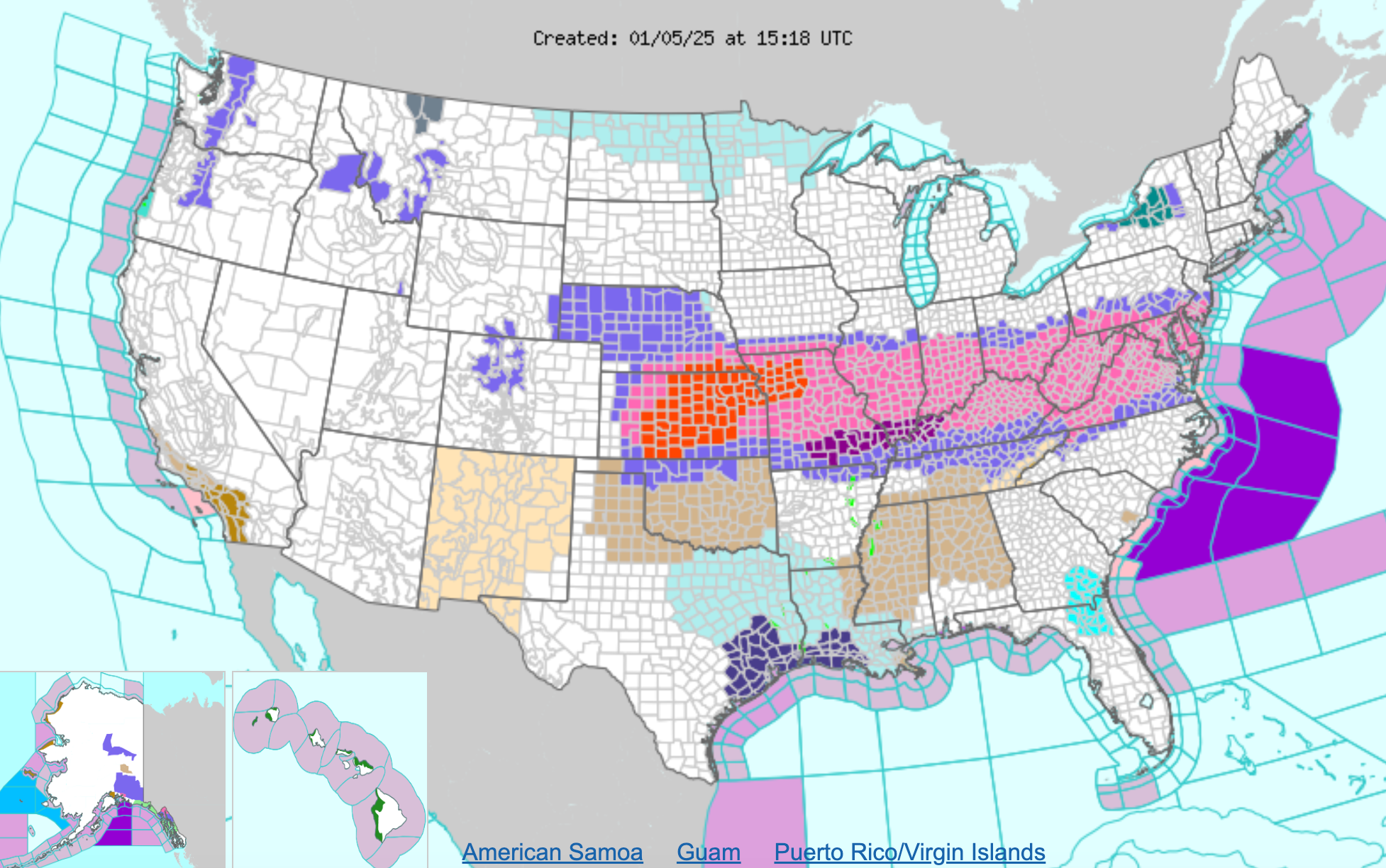
Some 70 million people are under weather alerts on Sunday as a winter storm bringing snow, ice and rain barrels across the US from the Central Plains to the mid-Atlantic.
Throughout the day, the storm will spread east from the Ohio River Valley and reach the mid-Atlantic by late Sunday or early Monday. The system will likely bring dangerous travel conditions and power outages to many throughout the country.
Dangerous travel conditions are expected as the storm brings the potential of over one foot of snow to many areas. Power outages are also likely in areas with heavy ice.
“For some, this could be the heaviest snowfall in over a decade,” the NOAA’s Weather Prediction Center said in a statement.
An ice storm has already hit southern Illinois, western Kentucky, and southeastern Missouri, with the National Weather Service warning travel is “strongly discouraged” in the region.
Many states, including Arkansas, Kentucky, Missouri and Virginia, have issued states of emergency ahead of the storm.
“This winter storm will likely cause significant disruption and dangerous conditions on our roads and could cause significant power outages – just 24 hours before it gets dangerously cold,” Kentucky Governor Andy Beshear said in a statement.
Thousands already without power as storm begins rampage
More than 25,000 people are already without power across Kansas and Missouri, according to PowerOutage.us, as a winter storm hits the Central Plains before heading toward the mid-Atlantic.
Kansas, Missouri and Nebraska could see winds over 40 mph and up to 15 inches of snowfall today, according to the National Weather Service. Meanwhile, up to 14 inches of snow could hit northeast Missouri through the Central Appalachians.
Katie Hawkinson5 January 2025 15:56
Arctic air to impact millions, reaching as far south as Florida
Freezing air from the Arctic will hit the eastern two-thirds of the US, the Associated Press reports, bringing strong and frigid wind chills to millions of people.
This Arctic blast will even impact Florida, according to the AP.
“The wind chills are going to be brutal,” Woodwell Climate Research Institute climate scientist Jennifer Francis told the outlet.
This wind could make for the coldest January in the country since 2011, Accuweather Director of Forecast Operations Dan DePodwin said.
This winter storm is expected to make road travel particularly dangerous, bringing heavy snowfall and ice to several states.
Katie Hawkinson5 January 2025 15:48
What to expect as winter storm pummels much of US
A “major winter storm” bringing “significant snow and ice” across the Central Plains and mid-Atlantic regions will strike today through Monday, according to the National Weather Service.
Kansas, Missouri and Nebraska could see winds over 40 mph and 15 inches of snowfall today. Meanwhile, up to 14 inches of snow could hit northeast Missouri through the Central Appalachians.
A “substantial area” of freezing rain is also expected from Kansas through the Central Appalachians today.
The mid-Atlantic region, including the major metro areas of Philadelphia and Washington, D.C., will see the worst of the storm tonight through Monday.

Katie Hawkinson5 January 2025 15:43
Brutal winter storm stretches from Central Plains to mid-Atlantic
A winter storm will barrel across the US today and Monday, bringing up to a foot of snow along with ice and rain to millions.
Some 70 million people are under some kind of weather alert this morning as the storm ramps up. Dangerous travel conditions and power outages are expected as the system moves from the Ohio River Valley to the East Coast late Sunday into Monday.
“For some, this could be the heaviest snowfall in over a decade,” the NOAA’s Weather Prediction Center said in a statement.
Follow along for live updates from The Independent.

Katie Hawkinson5 January 2025 15:38

