

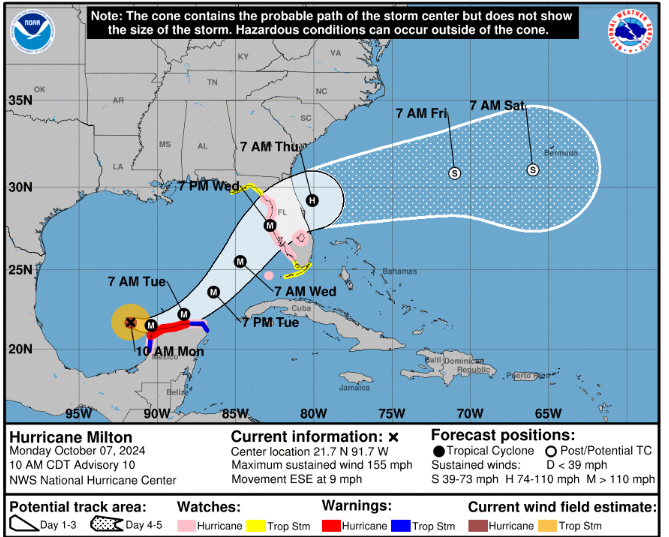
Florida is bracing itself for the arrival of Hurricane Milton on its west coast on Wednesday. It is already an extremely dangerous Category 4 hurricane forecast to move near or just north of the Yucatan Peninsula on Monday 7th and Tuesday before heading eastwards across the Gulf of Mexico. It has experienced extreme rapid intensification dropping from 972mbars to 945 mbars in just three hours with much lightning in the eyewall.
It is the first time in recorded history* that three active hurricanes have been seen in the Atlantic basin in October (or later). Kirk, Leslie and Milton. Kirk became an extratropical low on Monday 7th October and is heading for Europe. Leslie is out at sea and Milton is a major hurricane like Helene and Kirk before.
Mexico
The north coast of the Yucatan peninsula is under hurricane warnings with torrential rain expected, large waves and storm surge possible along with the wild winds. Even though Milton is forecast to stay offshore, the wind field looks intense over this part of Mexico and likely to produce rainfall totals of 2-4” with isolated totals around 6” across northern portions of the Yucatan Peninsula.
“Dangerous hurricane-force winds are expected across portions of the northern coast of the Yucatan Peninsula. A life-threatening storm surge with damaging waves is also likely. NHC”
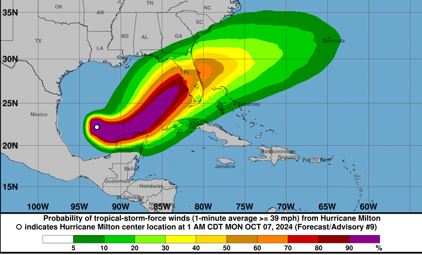
The formation of Milton in the Gulf of Mexico has raised eyebrows. Usually, cyclones swing in from the Caribbean and head northwards. This one formed in the west of the Gulf and is moving eastwards towards the west coasts of Florida with huge concerns about the storm surge.
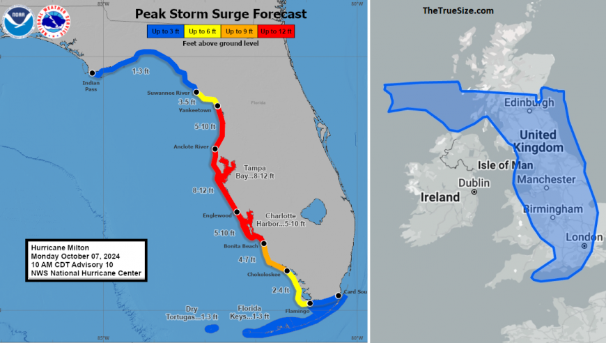
NHC Storm Surge forecast 10 and Florida compared to the UK, showing length of coastline under threat.
The storm surge from Helene affected the Tampa Bay region before the intense rains from that hurricane moved to North Carolina with devastating flooding. Helene’s landfall was further north in Florida’s Big Bend. Milton is forecast to make landfall along the west coast. The NHC show a potential track area, a cone of uncertainty and if you add on the Forecast Track Line it passes very close to Tampa Bay
Tampa International Airport “We will suspend flight operations at 9 a.m. Tuesday and reopen when safe to do so. Check directly with your airline for flight updates. TPA is not a shelter for people or vehicles.”
Mandatory evacuation orders have started with instructions for Florida. Governor Ron DeSantis has ordered the ongoing 24/7 debris removal, left after Hurricane Helene in late September. He reiterated that preparations should have begun and that people may have to evacuate. The evacuation plans are immense, with people being encouraged to move out not up (not up in high buildings) and to travel 10s of miles not necessarily 100s of miles, using less gas and not adding to the mass of traffic on the freeways.
RAINFALL: Rainfall amounts of 5-10” with localized totals up to 15”, are expected across portions of the Florida Peninsula and the Keys through Wednesday night. This rainfall brings the risk of considerable flash, urban, and areal flooding, along with the potential for moderate to major river flooding. NHC
This is a very serious situation, for Yucatan, Mexico early this week and for Florida midweek. And so soon after Helene which left the ground saturated.
* Philip Klotzbach states that whilst the NHC’s hurricane database goes back to 1851, there are likely underestimates and potentially missed hurricanes proper to the satellite era (1966 onwards).