

The next few days will experience very warm or hot conditions across parts of England and Wales, with temperatures perhaps touching 30C in southern England on Wednesday. Cooler and fresher conditions look to move in across all parts from the west by late Thursday, as an unseasonably deep area of low pressure arriving to the northwest pushes away the hot conditions on to the near continent. The frontal system bringing the change to cooler and fresher conditions will be weak, so no thundery breakdown looks likely, rather a band of cloud and perhaps patchy light rain moving through before the cooler and fresher conditions arrive. There will be plenty of blustery showers in the northwest.
Friday and next weekend will see a continuation of cooler and fresher conditions brought by westerly winds off the Atlantic. Eastern areas should stay mostly dry, bright or sunny, while western areas may see more in the way of cloud with occasional showers, perhaps longer spells of rain across northern and western Scotland – where it could be windy at times too.
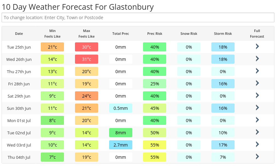
Glastonbury looking mostly dry
Glastonbury looks to stay mostly dry with any rain amounts look low and mostly from light and patchy rain as a weakening front clears through from the west on Thursday, while later on Saturday or Sunday morning may see a few passing light showers too. It will be very warm Tuesday into Wednesday, with temperatures reaching 26-27C, before turning fresher from the west on Thursday, behind that weakening front moving through from the west – which could bring a little light rain. Temperatures following the front Thursday in the cooler and fresher air, reaching 18-20C by day and a cool 8-10C by night. It will be breezier, too, Thursday & Friday before winds ease over the weekend.
It’s the first day of July next Monday, so what are the prospects for early July?
There was a signal yesterday for the Azores high to extend towards NW Europe as we head into early July, keeping the weather predominantly dry and settled across southern Britain, while northern areas were looking more changeable.
However, overnight runs have trended towards a more cyclonic westerly flow further south across Britain, thanks to a strong jet stream now modelled to shift further south across the UK than previous runs. This will mean areas of low pressure could track east across northern and perhaps cental Britain next week, tightening isobars, bringing windier and cooler conditions with rain or showers at times.
Having said that, wettest conditions will be most likely in the north, with southern areas drier, sunnier and warmer, but not immune from the odd shower or spell of rain moving through.
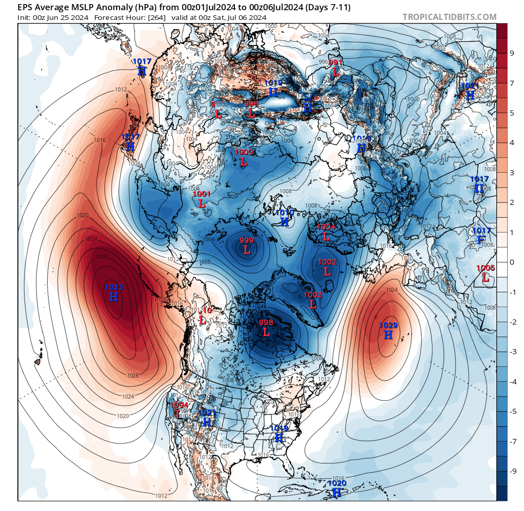
5 day MSLP average from EPS for 1st to 6th July suggests low pressure close to the north, with a westerly flow over UK = unsettled in the north and in the south at times too, Azores high never to far away from the south
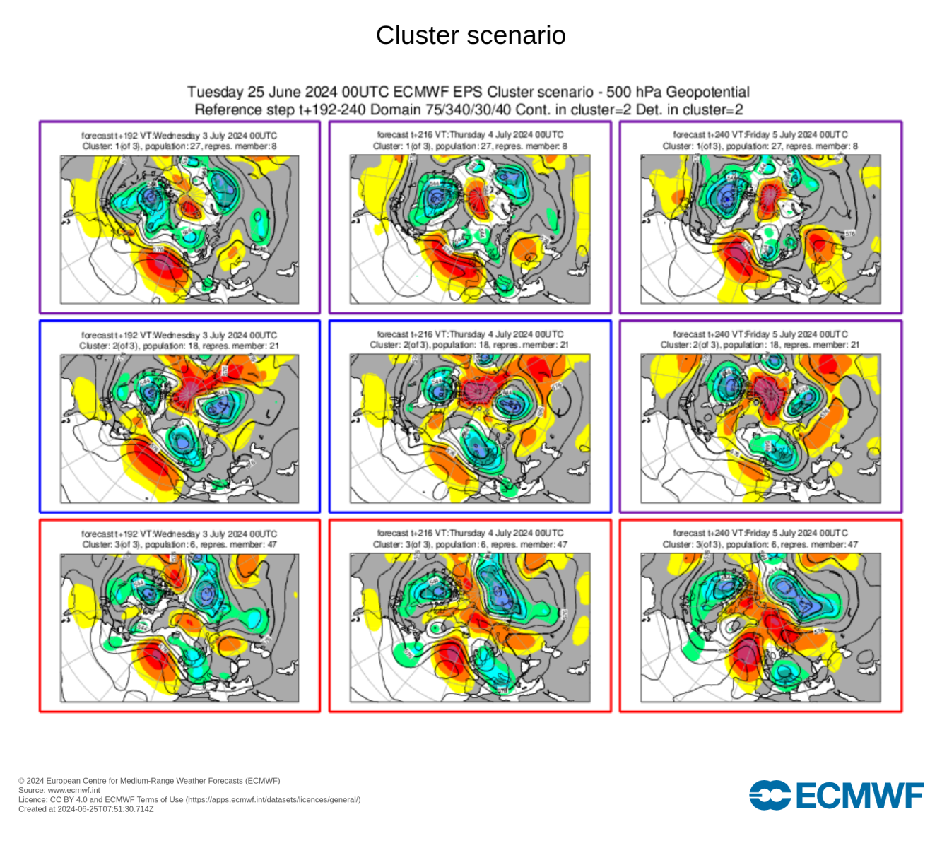
H500 mean and Clusters from 00z EPS run this morning point towards an increasingly unsettled picture into the beginning of July:

Given the flow is forecast to be generally from the west off the North Atlantic next week and it could be windy and cloudy with rain or showers at times, temperatures will likely be around average, but perhaps cool when cloudy. But when the sun appears, feeling warm, especially in the south. But no heat on the horizon after this week.