


- Milton will make landfall in Florida as a major hurricane tonight into early Thursday.
- Destructive, life-threatening storm surge is expected along the western Florida Gulf Coast.
- Devastating hurricane-force winds will occur near the coast and well inland through central Florida.
- Catastrophic and life-threatening flash flooding from rainfall is also expected.
- Several tornadoes are possible in the Florida Peninsula.
Hurricane Milton will make landfall in Florida tonight into early Thursday where it poses a major threat to life and property as it hammers the state with destructive storm surge, devastating wind damage, potentially catastrophic flooding rainfall and several tornadoes.
“Milton has the potential to be one of the most destructive hurricanes on record for west-central Florida,” the National Hurricane Center (NHC) said in its Wednesday morning discussion.
This is a life-threatening situation and all evacuations and storm preparations should be rushed to completion.
(MAPS TRACKER: Spaghetti Models And More)
Here’s the latest status: Milton is a Category 5 hurricane packing winds up to 160 mph as of 5 a.m. EDT. It is centered 300 miles southwest of Tampa and is tracking to the northeast at 14 mph.
Rainfall from the hurricane is spreading across parts of the state well in advance of landfall, as shown in the radar snapshot below.

Milton has grown in size over the last 24 hours, with tropical-storm-force winds now up to 125 miles from its center. It will continue to grow even larger on approach to Florida, which means its impacts will affect a big area.

Here’s where hurricane and storm surge alerts are in effect: Hurricane warnings cover much of central Florida from the Gulf side to the Atlantic side, including the Tampa Bay area, Fort Myers, Orlando, Cape Canaveral and Daytona Beach. This means hurricane (sustained winds of 74 mph or higher) conditions are expected within the warning area by Wednesday evening into early Thursday.
Various tropical storm watches and warnings cover other parts of Florida, southeast Georgia, southeast South Carolina and southern North Carolina, as shown in the map below.
A storm surge warning stretches along Florida’s Gulf Coast from Flamingo northward to Yankeetown, including Charlotte Harbor and Tampa Bay. Part of the Atlantic coastline is also in a storm surge warning, from Sebastian Inlet, Florida, northward to Altamaha Sound, Georgia, including the St. Johns River in northeast Florida.
This means a life-threatening water rise from storm surge is expected in these areas late Wednesday into Thursday.

Here’s the latest timing and intensity forecast: Milton will weaken gradually on approach to Florida because of increasing wind shear, but it should remain a major hurricane (Category 3 or 4) through landfall sometime overnight Wednesday into early Thursday.
It’s important to note that this weakening won’t reduce the impacts we see from Milton, including storm surge, destructive winds and flooding rainfall. As mentioned before, Milton will also grow larger on approach to Florida, allowing its wind, storm surge and rainfall impacts to sprawl out across a bigger area both within and outside of its forecast cone.
In short, do not let your guard down if you see Milton weakening on approach to landfall as this is expected and the hurricane will continue to be an extremely serious threat to Florida.

Impacts Forecast
Storm Surge
The latest National Hurricane Center forecast calls for storm surge to be as much as 8 to 15 feet above ground level if the peak surge coincides with high tide along the west-central Florida Gulf Coast, including Tampa Bay and Charlotte Harbor.
The tidal cycle will be in the process of rising toward high tide which is Thursday morning on the west-central Florida Gulf Coast when Milton arrives at landfall.
Storm surge will be most destructive near and to the south of where the storm’s center crosses the coast. If you’re in an area prone to storm surge, you should follow the advice of local officials and evacuate if ordered.
If the storm surge forecast materializes for Tampa Bay, it would be the highest there in more than a century. A track near or north of the bay would bring the highest surge potential there, while a track a bit farther south would shift the worst surge southward.
Storm surge should start building up on Wednesday before likely peaking Wednesday night into early Thursday.
Some storm surge could also inundate parts of Florida’s east coast as well as coastal Georgia and South Carolina because of winds blowing onshore when Milton passes by Wednesday night through Thursday.
Please note that adjustments to the storm surge forecast shown below are possible based on Milton’s exact track.

Wind Damage
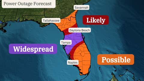
The most devastating winds capable of structural damage, downing trees and knocking out power will occur near where the center of Milton crosses the coast in west-central Florida and then tracks inland through central Florida toward the Orlando and Cape Canaveral areas. Power outages could last for days in these areas.

The timing for those strongest winds begins late Wednesday along the western Gulf Coast, then spreads east across central Florida through the first part of Thursday.
Areas farther away from the landfall point in northern and southern Florida will see some strong wind gusts as well that could at least down trees and cause scattered power outages.
Rainfall Flooding
Catastrophic and life-threatening flash flooding – and moderate to major river flooding – is expected from Milton in the central and northern Florida Peninsula.
Totals across these areas could be 6 to 12 inches, with locally up to 18 inches through Thursday.
NOAA’s Weather Prediction Center has issued a rare “high risk” flood threat for parts of central Florida, including the Tampa Bay and Orlando areas, for Wednesday and Thursday because of this excessive rainfall.
(For even more granular weather data tracking in your area, view your 15-minute forecast in our Premium Pro experience.)

Tornadoes
The threat of several tornadoes will exist Wednesday and Wednesday night in the central and southern Florida Peninsula. Some tornadoes could be strong, meaning EF2 or greater intensity.
An isolated tornado threat could linger into Thursday in east-central and southern Florida.

Recap Of Milton So Far
Tropical Depression Fourteen formed on the morning of Oct. 5 in the southwest Gulf of Mexico and shortly thereafter was deemed Tropical Storm Milton.
The storm then rapidly intensified into Hurricane Milton about 24 hours later at 1 p.m. CDT on Oct. 6.
The next day, Milton underwent another incredible round of rapid intensification. Winds increased from 90 mph at 1 a.m. CDT on Oct. 7 to 180 mph just 15 hours later at 4 p.m. CDT.

Milton’s 180 mph winds made it one of only nine other Atlantic hurricanes to hit that wind threshold or higher.
Its pressure dropped to 897 millibars, the lowest observed in any Atlantic hurricane since Wilma in 2005. That also ranks as the fifth-lowest pressure on record for any Atlantic hurricane.