Hurricane Milton takes aim at Florida
Chief Meteorologist Paul Dellegatto
TAMPA, Fla. – Hurricane Milton is still a Category 5 storm on Wednesday morning with maximum sustained winds topping 160 miles per hour.
Milton is expected to encounter a less favorable environment with strong wind shear, which meteorologists believe will lessen the intensity of the storm before it makes landfall.
As of 2 a.m. on Wednesday, Milton was located at 23.8N and 86.0W, which is about 360 miles southwest of Tampa.
According to the NHC, Milton wobbled earlier on Tuesday, but it is moving northeast at 12 miles an hour. The storm is expected to increase in speed and turn northeast through Wednesday night.
The National Hurricane Center says fluctuations in intensity are likely while Milton moves across the eastern Gulf of Mexico, but it is expected to still be a dangerous major hurricane when it reaches the west coast of Florida.
The NHC says a turn toward the east-northeast and east is expected on Thursday and Friday. Milton will move across the eastern Gulf of Mexico on Wednesday and make landfall along the west-central coast of Florida late Wednesday night or early Thursday morning.
Then, the storm is expected to move off the east coast of Florida over the Atlantic Ocean on Thursday afternoon.
READ: St. Pete construction cranes could pose a threat during Hurricane Milton
Hurricane-force winds stretch 30 miles out from the center of Hurricane Milton and tropical-storm-force winds extend outward up to 140 miles.
Governor Ron DeSantis declared a state of emergency for 51 Florida counties, while President Joe Biden has approved a federal disaster declaration ahead of Milton.
Watches and Warnings
A storm surge warning is in effect for Florida’s west coast from Flamingo northward to Suwannee River, including Charlotte Harbor and Tampa Bay, as well as the Sebastian Inlet Florida to Altamaha Sound, Georgia, including the St. Johns River.
A hurricane warning is in effect for Florida’s west coast from Bonita Beach northward to Suwannee River, including Tampa Bay and on Florida’s east coast from the St. Lucie/Martin County Line northward to Ponte Vedra Beach.
Hurricane conditions are expected in the hurricane warning area across Florida beginning late Wednesday through early Thursday.

Storm Surge
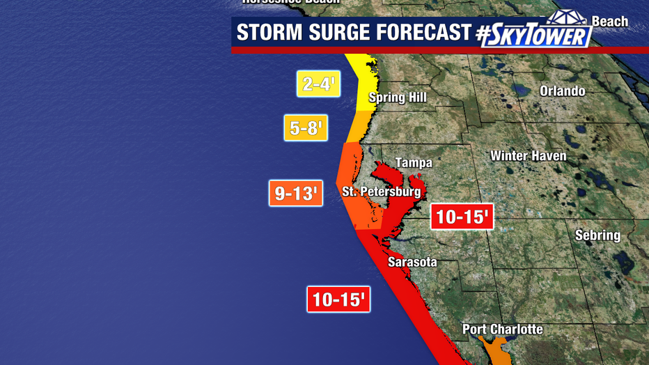
The National Hurricane Center says the combination of a dangerous storm surge and the tide will cause normally dry areas near the coast to be flooded by rising waters moving inland from the shoreline. The water could reach the following heights above ground somewhere in the indicated areas if the peak surge occurs at the time of high tide:
- Egmont Key, FL to Boca Grande, FL – 10-15 ft
- Tampa Bay – 10-15 ft
- Anclote River, FL to Egmont Key, FL – 9-13 ft
- Boca Grande, FL to Bonita Beach, FL – 8-12 ft
- Charlotte Harbor – 8-12 ft
- Bonita Beach, FL to Chokoloskee, FL – 5-8 ft
- Aripeka, FL to Anclote River, FL – 5-8 ft
- Chokoloskee, FL to Flamingo, FL – 3-5 ft
- Sebastian Inlet, FL to Altamaha Sound, GA – 3-5 ft
- Altamaha Sound, GA to Edisto Beach, SC – 2-4 ft
- Suwannee River, FL to Aripeka, FL – 2-4 ft
- Dry Tortugas – 2-4 ft
- St. Johns River – 2-4 ft

FOX 13 meteorologists say where Hurricane Milton makes landfall will make a huge difference in the amount of storm surge.
What is the difference between a watch and a warning?
A hurricane warning means that hurricane conditions are expected somewhere within the warning area. A warning is typically issued 36 hours before the anticipated first occurrence of tropical-storm-force winds, conditions that make outside preparations difficult or dangerous.
A hurricane watch means that hurricane conditions are possible within the watch area. A watch is typically issued 48 hours before the anticipated first occurrence of tropical-storm-force winds, conditions that make outside preparations difficult or dangerous.
Hurricane Milton: Mandatory evacuations begin in Tampa Bay Area
A storm surge warning means there is a danger of life-threatening inundation, from rising water moving inland from the coastline, during the next 36 hours in the indicated locations.
A storm surge watch means there is a possibility of life-threatening inundation, from rising water moving inland from the coastline, in the indicated locations during the next 48 hours.

How much rain will we get?
Florida can expect to see 6 – 12 inches of rain with some places getting up to 18 inches.
This rainfall brings the risk of catastrophic and life-threatening flash and urban flooding, along with moderate to major river flooding.
STAY CONNECTED WITH FOX 13 TAMPA:

