

There is concern for a major flooding event to unfold across parts of central and eastern Europe over the coming days, with weather models for a while now predicting an unprecedented deluge in the coming days, raising the spectre of catastrophic floods reminiscent of the devastating inundations that struck the region in 2013. Meteorologists in central European countries in are even suggesting this could be a one-in-a-150-200 year flooding event, with concern about the current weather models showing rare extreme amounts of rainfall in such a short period of time – which can have catastrophic consequences.
Weather models predict up to 500 litres of precipitation per square meter in some parts of Central Europe in the coming days. Uncertainties in weather models still exist, but the potential is there for a serious flooding event to unfold. It is likely there will be a threat of devastating floods for parts of several countries in central and eastern Europe, namely the south of Germany, the Czech Republic, Austria, western Poland and northwestern Slovakia.
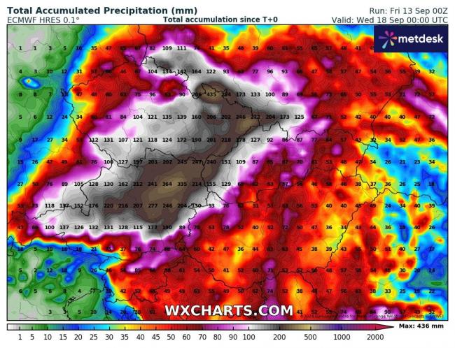
Current models indicate that the most precipitation will fall in eastern Czech Republic, northern Austria, northern Slovakia and southwest Poland, where 200 to 250 mm of precipitation could fall. Some models, such as ECMWF, are showing over 350 mm by early next week across parts of northern Austria and the far east of Czech Republic.
The Danube basin is also particularly at risk from destructive and potentially life-threatening flooding. If these catastrophic scenarios come true, the event of 2013, when the Danube was hit by historic floods, may be repeated. During that event, following a very wet spring in central Europe, an atmospheric blocking situation produced precipitation exceeding 300 mm over four days at the northern rim of the Alps, amounts that are normally seen over several months. This led to extreme flooding in June 2013 on the upper and lower Danube and the strength and intensity of this flood was devastating in Germany, Austria, Slovakia, Romania and Hungary. 25 deaths were recorded as a result of the floods; 11 in the Czech Republic, 6 in Austria, and 8 in Germany.
Also there was a severe flooding event in the first half of August 2002 and July 1997 – with record breaking rainfall amounts and intensities observed in central Europe.
If the current forecasts for over 350 mm to fall in a few locations are confirmed, more precipitation could fall than in 2013, which may make this a one-in-a 150-200 year flood – according to Austrian meteorologists.
An usual weather pattern is evolving this week across mainland Europe to bring the likely extreme flooding event. Unsually cold air for September of arctic origin that has swept down from the north across northwest Europe this week is now embedded across much of western and central Europe.
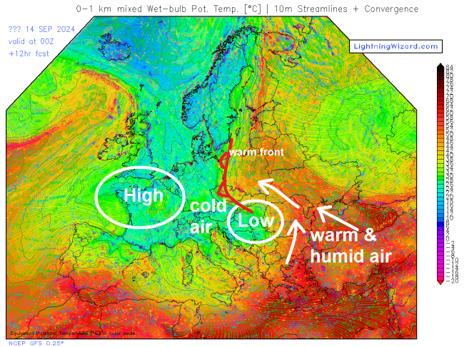
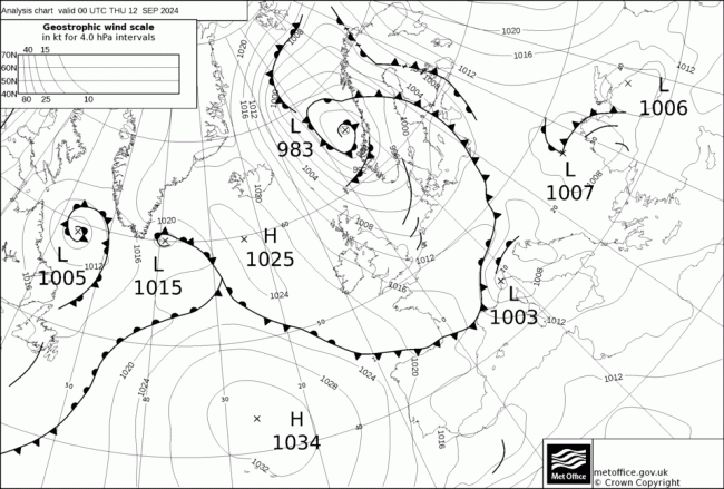
As the cold front bringing the colder arctic air approached the Alps on Thursday, an area of low pressure developed to the south of the Alps over northern Italy, due to contrast between the cold air moving in aloft over the Alps and very warm air from the Mediterranean.
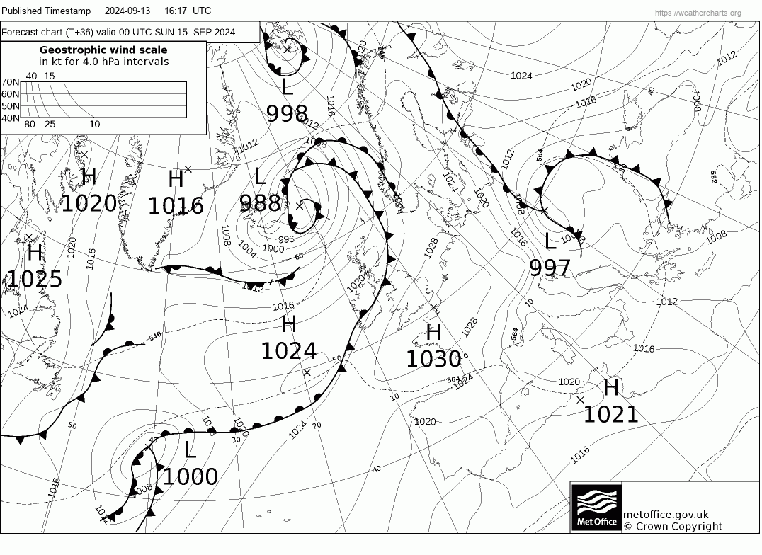
This low drifting slowly east over the Balkans today, but the frontal system wrapping around the north of the low, separating the cold air to the west and very warm and humid air being drawn north over eastern Europe to the east and northeast of the low, is forecast to become stationary across parts central and eastern Europe to end this week and through the weekend.
This stalled frontal system on the northwest side of the low over SE Europe today and over the weekend will bring long-lasting and intense rainfall, especially on the eastern side of the Alps across far southeast of Germany, eastern Austria, eastern Czech Republic, NW Slovakia and SW Poland. Also heavy snow is forecast in the eastern Alps, with 1-2 metres of fresh snow. From Thursday to Friday it snowed 60 centimeters within 24 hours at the Rudolfshutte weather station in the Hohe Tauern (2320 meters above sea level), the largest amount of new snow at this weather station in September since measurements began in 1980.
This extreme rainfall and snow falling in a short space of time will initially bring flooding from streams and smaller rivers in the upper catchment areas of where the heavy rain and snow falls, before filtering down through the major rivers in the area and also further afield downstream into Hungary and beyond into the Balkans, where much less rain is expected, bringing the threat of severe flooding, particularly along the Danube, Elbe and Neisse rivers. Larger rivers such as the Oder and Moldau are also likely to be affected. In Austria, the Czech Republic and Slovakia, numerous events have already been canceled due to the upcoming floods. The weather situation in the coming days is very similar to the major Danube floods in 2013 and Elbe and Oder floods in 1997 and 2002.
Czech authorities erected metal barriers or protective walls from sandbags in the capital Prague, while water was released from dams to make space in reservoirs. Residents have been warned to get ready for possible evacuations. Generally, floods and mudslides are expected in the areas mentioned, and snowfall in higher regions with problems on traffic routes and power outages.
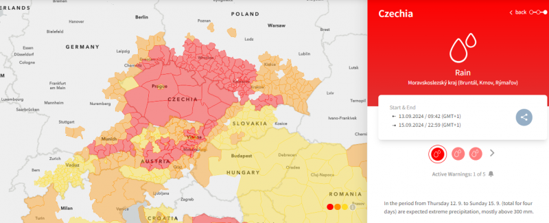
Red warnings for heavy rain and flooding are in force across parts of southern and eastern Austria, all of the Czech Republic, SE Germany, SW Poland and NE Slovakia.
This is the warning from ZAMG, the Austrian Weather Service:
From Thursday to Tuesday it rains frequently and heavily in the northern reaches of the Alps and in the Vienna Woods. The intense rain will saturate the soil and small-scale flooding is likely. Streams and rivers can overflow their banks. In addition, disruptions to road and rail traffic are generally possible. During the warning period, 150 to 200mm of rain is likely over a large area; in northern locations, rainfall amounts of 300mm to 400m can occur. A daily update of the warning follows.
Join the discussion on the Netweather forum talking about this possible severe flooding event