

The remnants of Hurricane Ernesto are set to batter parts of the UK this week, bringing up to 150mm of rain and wind gusts of up to 60mph, the Met Office has warned.
The wet and windy conditions look set to put a dampener on Britons trying to enjoy their August summer holidays this week, after weeks of wildly inconsistent weather across the country. Ernesto tore through the North Atlantic this week, with winds of 100mph leaving hundreds of thousands of people in Puerto Rico and Bermuda without power.
The Met Office has now issued a series of weather warnings for heavy rain in the UK next week, as a low-pressure weather system imbued with the leftover energy of Ernesto – the fifth named storm and third hurricane of the Atlantic hurricane season – makes landfall in Britain.
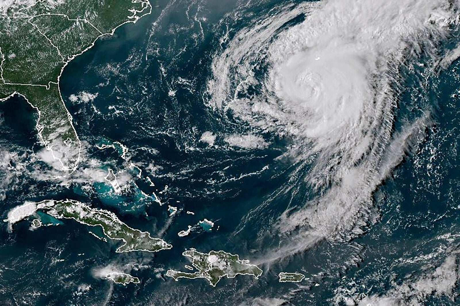
While Ernesto has already weakened to a tropical storm and remains on the western side of the Atlantic, it will wither further as it moves further into cooler waters and becomes absorbed into a more typical weather front moving toward Britain.
Ahead of the bank holiday weekend, weather will remain unsettled for many areas, with outbreaks of rain or showers spreading in from the west, the forecaster said. The Met added that the wettest conditions are likely to be across northwestern parts of the UK, with the southeast tending to be drier. Strong winds are also likely starting on Friday, mostly affecting the west and north of the country.
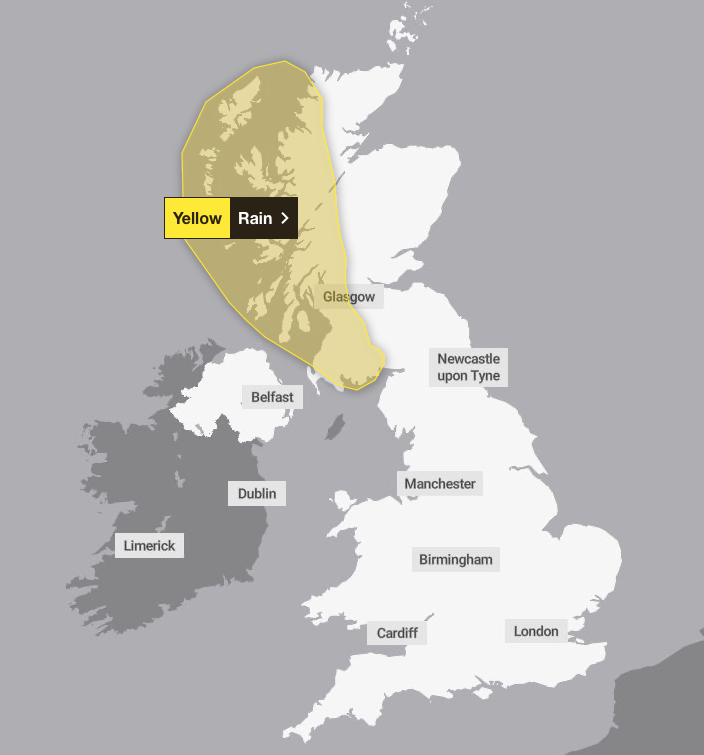
The remnants of the hurricane will be heaviest in south-east Scotland, where a yellow rain warning will be in place from Monday afternoon onwards.
Andy Page is a Chief Meteorologist with the Met Office. He said: “During Monday, the band of rain will gradually move east across the UK. Within the warning area we can expect to see 25-35 mm of rain, with some of the wettest areas receiving up to 60 mm. The rain will be accompanied by strong southerly winds.”
Met Office forecaster Craig Snell added: “Because the tropical systems just have so much warmth and a lot of moisture in them, remnants of the warmth and remnants of the moisture will be still there in that weather system on Wednesday and Thursday, so it will enhance the rainfall. “
The national forecaster’s deputy chief meteorologist Tony Wisson added: “Newspaper headlines suggesting that Ernesto itself is set to batter Britain aren’t accurate.
“The once powerful system itself will break down before it reaches us, but the warmth and moisture it once contained will become entrained within a mid-latitude frontal weather system.
“This will lead to unsettled conditions for the UK, especially across the north and west, with heavy rain and strong winds expected here.”
While August is usually associated with fine and settled weather, wet and windy fronts such as this are not uncommon, Mr Wisson said.
Forecasters have issued two yellow weather warnings for rain in Scotland, with up to 150mm expected to fall over some hills and 75 to 100mm more widely within a 24-hour period. Some parts of the Highlands typically see fewer than 100mm of rain fall throughout the whole of August.
The warnings cover much of Dumfries and Galloway from 2pm on Monday until just before midnight, and all of western Scotland north of Glasgow and Stirling for most of Wednesday and Thursday.
The rain will be accompanied by strong south-westerly winds, with gusts reaching 50-60mph possible on the coast and around the islands.
The Met Office warned of possible delays to public transport, spray and flooding on roads, as well as potential power cuts and flooding in homes and businesses.
There is a small chance that the spring tide will generate large waves that could result in injuries and a danger to life in coastal areas on Wednesday and Thursday, the weather service added.
Hurricane Ernesto left almost a million people without power in Puerto Rico, which was battered with winds of more than 80mph and 250mm of rain. It went on to hit Bermuda with sustained winds of 85mph, generating a storm surge with more than 10ft waves.
Elsewhere in the UK, the forecast looks “quite unsettled” and it will be a cooler week for many after a high of 34.8C in Cambridge was recorded on August 12.
It will turn increasingly windy during Monday afternoon away from the southeast of England, with the strongest winds across the north and west, with gale likely along some Irish Sea coasts, the Met Office said.
The south and southeast of England are expected to enjoy the best of the drier weather next week with some warmer spells and highs of around 26C in East Anglia, Mr Snell said.